By Erika Norton, WPAOG staff
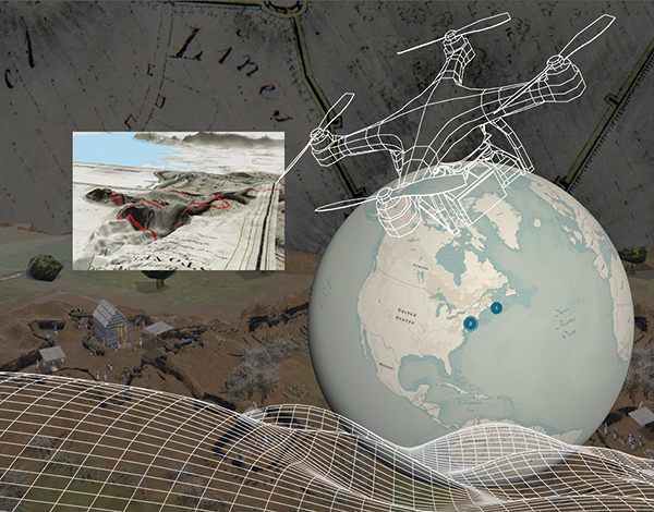
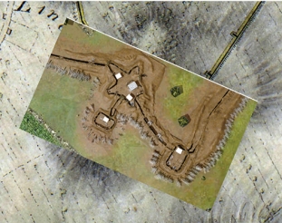
Today, drones with high resolution cameras are becoming standard learning tools across academic fields. It may be surprising to learn that, of all the departments at the U.S. Military Academy, the one that is making waves for its creative use of these small, unmanned aircrafts is the West Point History Department, more specifically its Digital History Center (DHC). It’s true: DHC is using drone technology to help cadets visualize the past.
By taking aerial photos and video of landscapes using drones, cadets who are History majors are now able to create accurate geographic information system (GIS) maps, 3D-printed topographic models, videos, and other digital presentations to better visualize the history of different landscapes. Last year, firsties were able to use the department’s drone imagery to create GIS maps of what West Point and the greater Hudson Valley region used to be like and how the terrain impacted key battles during the American Revolution.
With the DHC drone program fully in place, cadets have only begun to scratch the surface of how they can use not only drone data collection but other digital technologies to create visual, interactive projects and form a deeper understanding of the nation’s history.
“We are trying to make the door as open as possible for cadets to run with this,” said History instructor Major Tom McShea ’10, who has been instrumental in advancing the program.
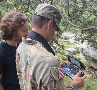
Major Jacob Henry ’12 and Captain Cameron Colby, also History faculty members, joined the effort in the fall of 2023, with Colby capturing drone footage that explores the fortifications on and around West Point dating back to the founding of the original fortress. Then, in the summer of 2023, Henry and Colby led six cadets on an Academic Individual Advanced Development (AIAD) assignment, a Margin of Excellence initiative, to study the Battle of Brooklyn in 1776, which featured the largest amphibious assault in history prior to the D-Day Normandy landings in 1944.
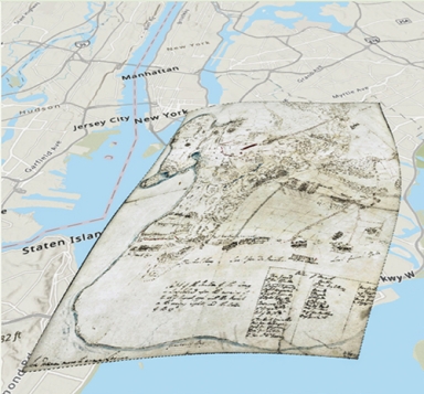
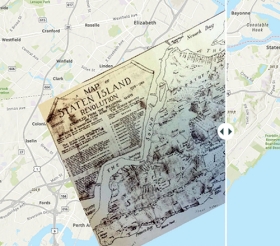
Collectively, cadets and faculty developed an assortment of StoryMaps, each one explaining a different aspect of the battle. Using research from the AIAD, as well as original maps, they worked with a digital artist to develop a fully interactive map of the battle location as it appeared in 1776, which was a first for this area, as it has been extensively terraformed into the city landscape of today.
For his part in the project, Cadet Matt Knutson ’25 focused on how General Henry Clinton maneuvered throughout the battle. Using the StoryMap technology, Knutson guides the viewer through the historic map, which, according to Colby, is a rare map and not commonly used to talk about the 1776 battle. Knutson was even able to use the old maps to contend that the historically significant Rising Sun Tavern in Brooklyn is in a different place than is often cited.
“The project really brings something to life that is impossible to see in Brooklyn today,” Colby said. “At the locations around West Point, we can stand on the ground and kind of sense the past. Brooklyn, you cannot. So, these re-creations become amazing tools for visualizing American history.”
Another benefit of this technology is that it allows cadets, and anyone in the Army, to go on “staff rides,” which are trips to historical sites, virtually. Doing so saves money and allows cadets to visit locations that sometimes don’t exist anymore.
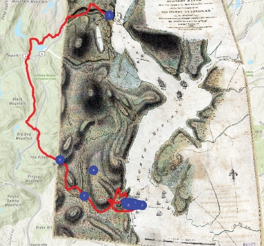
In June 2022, then-Cadet Max Kohmetscher ’23 walked all 12 miles of General Anthony Wayne’s attack route during the 1779 Battle of Stony Point while carrying a GPS, collecting footage and photographs of key points of the battlefield. He went on to create a digital staff ride, allowing Stony Point to come to life for researchers, educators, and students who do not have the means or opportunity to travel to the Hudson Valley to see it for themselves.
“There’s nothing that can quite replicate standing on the ground and trying to visualize how the battle transpired on the actual battlefield,” McShea said. “Well, this technology shows that you can do a staff ride without traveling. You can do everything short of standing on the ground, and still get a really firm understanding of how that battle was fought and why it transpired the way that it did.”
According to History professor Colonel Seanegan Sculley, these digital history resources can really help a student, whether a cadet or a graduate student, better visualize what occurred, especially when dealing with complex military history, which is often influenced by the surrounding environment and topography.
Often, students rely on written documents as historical resources. A student might read an account from a soldier at one end of an American defensive line, an account from a British junior officer who was an aide to one of the generals sitting more towards the rear, and then perhaps an account from an American company commander at night.
“These accounts are coming from different perspectives, and the history student is trying to stitch them all together,” Sculley said. “Maps have always been the way we receive a visualization from that past, but now we can take every written record, as well as the work from cartographers and engineers, and use digital techniques to mash all the data together to determine if it makes sense. And, if it does make sense, now I can really visualize it; now, I can understand why the British made the decision that they made at this point or why the Americans chose to do X, Y or Z.”
“The project really brings something to life that is impossible to see in Brooklyn today. At the locations around West Point, we can stand on the ground and kind of sense the past. Brooklyn, you cannot. So, these re-creations become amazing tools for visualizing American history.”
— CPT Cameron Colby, Department of History Faculty
Helping cadets and faculty create these digital mapping projects is cartographer Jeff Goldberg, another key individual involved in the advancement of DHC. Dating back to its earliest days, the U.S. Military Academy has always had a cartographer on staff and has recognized the importance of drafting maps for military instruction.
As technology continues to advance, a cartographer’s job continues to advance as well. Given that previous cartographers have already converted the department’s maps into digital formats, Goldberg’s focus has mainly been to take those digital maps and implement them into their online textbook, West Point History of Warfare. His work includes animation, terrain visualization, and customizing maps to focus on not just specific battles but on individual units within those battles, depending on the instructor’s requirements.
“While creating a new map in the past required using a pre-drawn basemap, which is somewhat limiting in scale, or starting a new map from scratch, which is time intensive, we can very quickly swap out entire battles and time periods in a matter of minutes,” Goldberg said. “There was no way to animate our books in the past, and now on one screen we can show the progression of entire armies moving across a field and possibly use interactive elements to dive deeper into the story.”
With the introduction of drones, 3D scanners, printers, and other tools, Goldberg said the department is looking forward to introducing new elements into its repertoire. In the future, DHC, which is a West Point Ready Campaign need, is looking to add virtual reality and augmented reality, particularly with the fortifications at West Point. The department has already started experimenting with Unreal Engine, a video game-like software that creates 3D photoreal visuals and immersive experiences. With the 250th anniversary of the American Revolution coming up, there’s a lot of interest in using this technology, not just among cadets but among faculty as well.
“We’re starting to work on all of this so that we can build up our capacity,” Sculley said, “When cadets or graduate students are interested in, say, the Seminole Wars or the Trail of Tears or the Harlem Hellfighters in World War I, we’re ready to show them all of the different things we can do right now.”
What do you think? Click here to answer 3 questions.