Mapping the American Revolution in the Hudson River Valley
Situated in the heart of the Hudson Valley and a Revolutionary War fortress itself, the United States Military Academy at West Point is in a unique position to leverage its resources, expertise, and historical vantage point to advance the public’s historical understanding of the region. In 2022, West Point’s Digital History Center launched “Mapping the American Revolution in the Hudson River Valley,” a multi-year, collaborative project between West Point cadets and faculty that will represent the Revolutionary Era of the Hudson Valley through a series of digital, interactive story maps.
For the past two years, WPAOG was selected as a recipient of the Americana Corner Preserving America Grant. This generous support allowed West Point’s Digital History Center (DHC) to begin producing an interactive digital map related to the Battle of New York in 1776 as part of this multi-year project. Tom Hand ’82 is the founder and president of Americana Corner, which he created in 2020 to share stories of the significant events, documents, and influential leaders that helped create and shape the United States. The Preserving America Grant Program was established to help organizations tell the story of America from its founding era through its first century as a nation. These grants fund a diverse range of projects, including restoring historical objects, creating educational displays, and making improvements to historic sites that will enhance the visitor experience.
For much of its history, New York’s Hudson Valley consisted of a network of isolated towns, villages, farms, and fortresses connected by one main thoroughfare: the Hudson River. The Hudson River was not only the primary trade route connecting Canada and the Great Lakes to New York City, but also decisive terrain in military operations throughout the colonial era— particularly during the American Revolution. For this reason, the Hudson Valley was famously referred to by George Washington as “the key to the continent.”
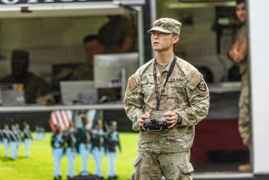
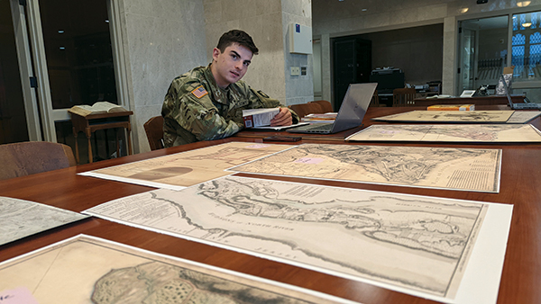
Through this project, West Point cadets and faculty compile and consolidate historical maps, modern aerial and ground imagery, and employ unmanned aerial systems (UAS) to improve existing products, create new ones, and leverage them in support of education and outreach. The project will explore Hudson Valley battlefields, historical sites, roads, and fortifications related to the Revolutionary War to provide a platform that represents each as part of a whole, interconnected, and even dependent network. In this manner, the disciplines of GIS and history come together to provide students, educators, and researchers a comprehensive resource where they can better understand and visualize the struggle to control the Hudson Valley during the Revolution.

This project is now in its third year and has already produced maps, diagrams, animations, and interactive videos chronicling two key battles within the valley. The first iteration introduced the concept of historical overlay onto modern terrain at the current site of the 1779 Battle of Stony Point. The second year went beyond the original scope to create a StoryMaps Collection of the 1776 Battle of Long Island, bringing to life the largest battle of the Revolutionary War. The project is now mapping the final elements of the 1776 New York Campaign, including the Battles of White Plains and Fort Washington and includes the digital recreation of Fort Washington to scale and the animation of the British assaults through Westchester County. The DHC will recreate the region of Fort Washington in exacting detail through the strict analysis of contemporary maps, first-hand accounts, and visual confirmation through on-the-ground site visits. Further analysis will help build an animated map of British and American movements through Westchester County during weekslong maneuvers leading to the Battle of White Plains. The end result will be a digital story map that includes virtual flyovers, contemporary 18th-century maps overlaid on 3D terrain, and 3D models of fortifications with hotspots to explain how and why those forts were designed as they were.
The DHC at West Point is a Margin of Excellence funding need in the West Point Ready campaign and will continue to serve as a content-generating digital laboratory, create opportunities for cadets to experience history through interactive augmented and virtual reality products, and widen the scope of historical inquiry by building customized, codable databases of historical information. As the world of information gathering, analysis, and dissemination rapidly changes, it is imperative that West Point engage tomorrow’s officers in the robust lessons of yesterday and equip them with full proficiency in cuttingedge technology so they can succeed in leading the Army of the future anywhere in the world.
All content from “Mapping the American Revolution in the Hudson River Valley” project is accessible through the Digital History Center’s website.
Read more about West Point’s Digital History Center in West Point magazine.
Explore the 3D map of the 1776 Battle of Brooklyn.